![]() I love hiking. This fall I’ll be spending some time in Wyoming’s Bighorn mountains, which is one of my favorite spots on Earth, as well as Montana’s Bitterroot mountains and some of South Dakota’s Black Hills. And of course, doing some hiking on weekends here at home in Oregon.
I love hiking. This fall I’ll be spending some time in Wyoming’s Bighorn mountains, which is one of my favorite spots on Earth, as well as Montana’s Bitterroot mountains and some of South Dakota’s Black Hills. And of course, doing some hiking on weekends here at home in Oregon.
For me, heading in to the woods requires more than a little planning. First, my free time is usually at a premium so unfortunately I don’t usually have the option of just getting in my car and driving off towards the mountain on a journey of exploration. I want to know where I’m going and what the trails are like when I get there. Second, I usually hike with my German Shepherd dog, so I want trails that are dog-friendly and not infested with, say, rattlesnakes.
There’s lots of ways to get info – asking friends, asking on forums/Reddit, government publications, hiking books. But lately I’ve been using the AllTrails app and while it isn’t perfect, it’s been serving me pretty well.
Let’s Get it Out of the Way: the Cost
The web site can be accessed without paying a fee, and you can do a lot of planning and reading there without paying a dime. If you want to download maps, you’ll pay $30/year or $2.99/month. The later might be attractive if you’re more of a summer hiker.
What Can You Do with AllTrails?
To start, you can look at a giant map and pick out trails! Here’s what the Explore map looks like:
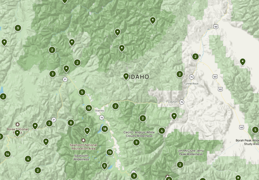
Each of those points is a trail you can click on to get info. If you do, you’ll get a ton of info, such as length, elevation changes, easy/moderate/hard ratings, and a description of the trail with notes about seasonality, how popular it is, dog policy, etc.
But the real power is in the community, because you also have access to reviews and photos. I find both of these invaluable. Real examples from trails I’ve researched:
- Recent post pointing out where poison ivy is
- Comments not to go right at the first turn because you get into private property
- Notes about how a section of the trail has shade or doesn’t
- Notes about how the road leading to the trailhead requires AWD
- “I was there last month and on the return leg I saw a mountain lion print in the boot print I’d made on the way out…”
- “The feral goats are pretty aggressive” (LOL!)
Etcetera. It’s like having local guides – really neat.
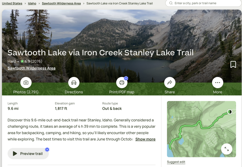
Plus there’s tons of photos from trails, which combined with comments gives you a real feel for what the trail is like. Being able to look at the trail really makes it come alive and lets you decide if the right trail for you.
You can organize trails into lists, which is great for planning.
The App and AllTrails+
The app offers navigation, which I find pretty useful, and this includes elevation tracking. When you’re an hour into the trail, it’s nice to look at your phone and see if you’re over the big hump or it’s still coming up.
It also provides health data (steps, distance, all the usual metrics). I’m an iOS guy and it feeds into Apple’s health app.
This info can be downloaded if you have AllTrails+, and that’s practically required because…go figure…you’re out of cell phone range. Note that if you have a different GPS system, the site offers downloads into a ton of other formats (Garmin, and a galaxy of others).
AllTrails+ also allows you print and customize maps from the site. Sometimes for finding context in the surrounding region and routes to the trailhead this is helpful.
More info on AllTrails+ here.
What Could be Improved?
One thing that I’m sometimes frustrated by is getting to the trailhead – though this frustration predates the Internet! It’s part and parcel of the experience: you’re going somewhere remote, and you can’t always expect road signs.
Sometimes the community fills this void by putting comments about how to find the trailhead. For popular trails near big cities, the “Blah Blah Trailhead” in Google Maps may very well find it. But for others, you sometimes have to figure out exactly how to get there.
One trick I’ve learned is to click Directions on the web site, and then note the URL that it’s passing to Google Maps. It’ll be something like this:
https://www.google.com/maps/dir/Current+Location/44.19865,-115.01371
That last part are the GPS coordinates to the trailhead, which often aren’t put in the trail details page. When I’m making notes for trails, I save those to locate it. Also, putting those into Google Maps and then figuring out the route to the trail is helpful.
Overall, I’ve been quite pleased with AllTrails and have used it a lot for planning and hiking.
Do you use AllTrails? What do you think? Or is there another site/app you prefer? Please comment below!
One Final Question
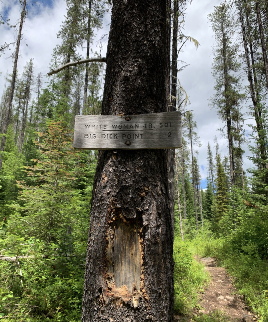
This photo is from Telichpah Trail 196 in Northern Idaho. Um…what the hell goes on there?!?
raindog308 is a longtime community LETizen, technical writer, and self-described techno polymath. With deep roots in the *nix world, he has a passion for systems both modern and vintage, ranging from Unix, Perl, Python, and Golang to shell scripting and mainframe-era operating systems like MVS. He’s equally comfortable with relational database systems, having spent years working with Oracle, PostgreSQL, and MySQL.
As an avid user of LowEndBox providers, raindog308 runs an empire of LEBs, from tiny boxes for VPNs, to mid-sized instances for application hosting, and heavyweight servers for data storage and complex databases. He brings both technical rigor and real-world experience to every piece he writes.
Beyond the command line, raindog308 has a life-long love of German Shepherd Dogs, high-quality knives, target shooting, theology, tabletop RPGs, playing guitar, and hiking in deep, quiet forests.
His goal with every article is to help users, from beginners to seasoned sysadmins, get more value, performance, and enjoyment out of their infrastructure.
You can find him daily in the forums at LowEndTalk under the handle @raindog308.


Leave a Reply